
The Great Rockies Trip Report
by Geoff Allsup
Summer 1994

The following is my trip report for a 2 week loaded bike tour from West Glacier, MT to Jasper, AB. My 23 year old son, Ben, and I (43 years old) made the trip together, while my wife, Kim, and daughter, Nora, followed approximately the same route in the car. We drove our aging Toyota van out from Cape Cod, MA to Missoula, MT in a marathon drive, then after a night in a motel in Missoula, headed up to West Glacier and spent Sunday night, 24 July, in the Glacier NP campground there. The plan was for Ben and me to ride our loaded bikes from West Glacier to Jasper, and only meet up with the Kim and Nora a couple of times along the way. In the end, we met up a little more often, and skipped a stretch in British Columbia because of time constraints, but while we rode, we carried all our supplies and camping gear. Anyway, here it is.
Day 1 - Monday, 25 July 94 - 15 miles
- West Glacier, MT to Avalanche Creek CG, Glacier NP
We leave the campground at 10:20 am (not an early start!). This is our first day on the road, intentionally short, and flat along Lake McDonald. At 10:30, only a couple of miles from the campground (CG), we see a sign on Going-to-the-Sun Road which says "No bikes next 9 miles from 11 am to 4 pm daily" (oh, great!) I knew there was such a prohibition on Logan Pass but was not expecting to see it here also. In any case, we have just enough time if we move along, and so we ride the next nine miles along Lake McDonald at 20+ mph with full loads! We are able to take it a little slower the last few miles to Avalanche Creek, as the road climbs a bit away from the lake. Avalanche Creek is nestled in amongst some steep mountainsides a few miles from the beginning of the serious climbing of Logan Pass.
We get a campsite, and Kim and Nora arrive shortly thereafter (they had expected to get here first and get a site). We get settled and then go for the couple of hour hike up Avalanche Creek to Avalanche Lake, a glacial lake spectacularly surrounded by high peaks with several awesome glacial fed waterfall/streams tumbling at least a couple of thousand feet down to the far end of the lake. This is a popular hike, but well worth it for the views, and cool by the water.
Day 2 - Tuesday, 26 July 94 - 36 miles
- Avalanche Creek CG to St. Mary, MT - Going-to-the-Sun via Logan Pass
After a quick breakfast, Ben and I leave Avalanche Creek CG at 6:30 am. We have to reach Logan Pass by 11:00 am as the road is restricted for bicycles from 11 am to 4 pm - too many RV's, I guess.
The first few miles are easy grade with a view of the road rising toward the east against the distant mountainside. It is very quiet and quite cool this morning. As we round a sweeping curve to the left, the climb begins in earnest. We find out later that the road has a constant grade of about 5% for the next 11 miles - 3000 feet of climbing. The climb is steady the whole way - no flat spots except briefly at the hairpin turn about 5 miles into the climb. Just before the hairpin, we stop to take pictures in the short tunnel section on the road. Cutouts in the side of the tunnel frame the views of mountains to the SW (?). The climb continues in the cool early morning shadows after the hairpin turn. We will not reach sunlight til the last half-mile near the top of the pass; we are literally Going-to-the-Sun at this hour of the day. Our progress is good in spite of the steady climb and loaded bikes (we aren't carrying full touring loads since we will meet Kim and Nora tonight at St. Mary to camp, just cameras, food, tools, and some extra clothes just in case). As we break into the sun near the top of the pass, we stop to take pictures of the mountain goats in the road and meadow here. We reach the pass at about 9:20 am after about 2 & 1/2 hours of actual riding - quicker than expected. Logan is supposed to be the toughest pass on the trip, so I'm happy with our performance (Ben does get off and walk a couple of short stretches - I think he has probably not done enough pre-trip riding).
After a picture at the Logan Pass sign, we meet Kim and Nora, who passed us in the car during the climb, at the Logan Pass Visitor Center. We have our first light lunch of the day at 10 am here.
We head down to St. Mary at 11 am. The downhill is a real flyer for a while, but then there are some more ups and downs (this will be a constant occurrence in spite of the indications of the route profile on the Bikecentennial maps - by the end of the trip I will award 2 thumbs down for the usefulness of the route profiles!). Along St. Mary Lake we run into some road construction and have to wait our turn to pass through a stretch of one-way gravel.
We arrive at St. Mary, after spending some time at the NP St. Mary Visitor Center, at about 12:45 and proceed to Johnson's Cafe and Campground (with showers!) where we will meet Kim and Nora to spend the night. We are ahead of them now, and have a good second lunch at the cafe - this climbing must burn a lot of calories because we're starved. Kim and Nora arrive in the middle of this lunch and help us eat it!
Later, after setting up camp and snoozing for a while, we have dinner at the cafe. Good food and lots of people (not many choices in town and this is something of a local tradition evidently).
Day 3 - Wednesday, 27 July 94 - 48 miles
- St. Mary, MT to Waterton Lakes, AB (townsite CG)
We say goodby to Kim and Nora for a couple of days and depart the campground at 9 am. This turns out to be one of the tougher days of the trip as there is far more climbing than expected on the route profile. (Remember two thumbs down!) After the turn onto Chief Mountain International Highway (Hwy 17), where we have soda at a small service station/convenience store on the corner, there are NO SERVICES until Waterton townsite. We do not see the indicated service station near the crossing of the Belly River at about 30 miles into the ride. Even the spring indicated on the map at about the 35 mile point is closed - bad water.
We leapfrog a couple of tour groups all day (one from Backroads Touring - we will see this Backroads tour, and another in Banff/Jasper many times).
There are 2 fairly hard climbs this day, as well as several lesser bumps. After much climbing in the first half of the day, we arrive at the Canadian border about halfway DOWN a screaming downhill and are greeted by 20 questions on gun ownership by the Canadian border guard. The guy ahead of us in the Suburban with MT plates gets sent over to some other border guards and we last see him sitting there while the guard is checking his 9mm automatic (from under the driver's seat?) to see if it's loaded. We never do see this guy pass us later and wonder if they sent him back - creepy.
After the border crossing, we finish the long downhill to the Belly River, and then begin more steady climbing over the next ridge line towards Waterton. We are running low on water and are not happy to discover the spring is closed. When we finally crest the last ridge before another screamer of a downhill towards the Hwy 5 turnoff to Waterton, we try to wait at an overlook to see if an RV will pull in - where is an RV when you want one! No luck after a few minutes, so we are nursing the last half pint of water between us to get to Waterton. As we turn in to Hwy 5, we stop at the entrance station to ask about campsites (there may be a couple left in the group area, but it's filling fast) and water (none til town, and they don't even drink the bottled water they have in the shack with them - oh, great). A couple of miles towards town (and yes, it's uphill for the view once more) I spy an RV at the overlook and go up to the door and ask if I can get a bit of water. They are happy to give us water with ICE, and we talk to them briefly about our trip before riding off to the townsite.
At Waterton townsite we stop at the visitor center across from the Prince of Wales Hotel (the grand hotel you see in all the pictures of Waterton Lakes) and they tell us the CG is full, but maybe we can find someone to let us share a site - oh real great!
At the CG entry station, they say "oh, you're the 2 guys on bikes who were at the entrance a while ago. They tried to call you back as you rode off to get your names, then they called ahead and we held the last site in the walk-in area for you". Whew! We're all set. How nice of the folks at the initial park entrance station to call ahead. We pay our $13 Canadian for the site, and when they ask if we would mind sharing the site, I say "No, that's fine" since I know we'd really appreciate it if we hadn't found an empty site available.
We quickly set up our tent and dump some stuff in the bear-proof storage lockers, then head back to town (only a few hundred yards actually) for lunch at a restaurant by the lake. We're starved and end up splitting one lunch as an appetizer before each having our own! The waiter looks at us a little funny but manages OK.
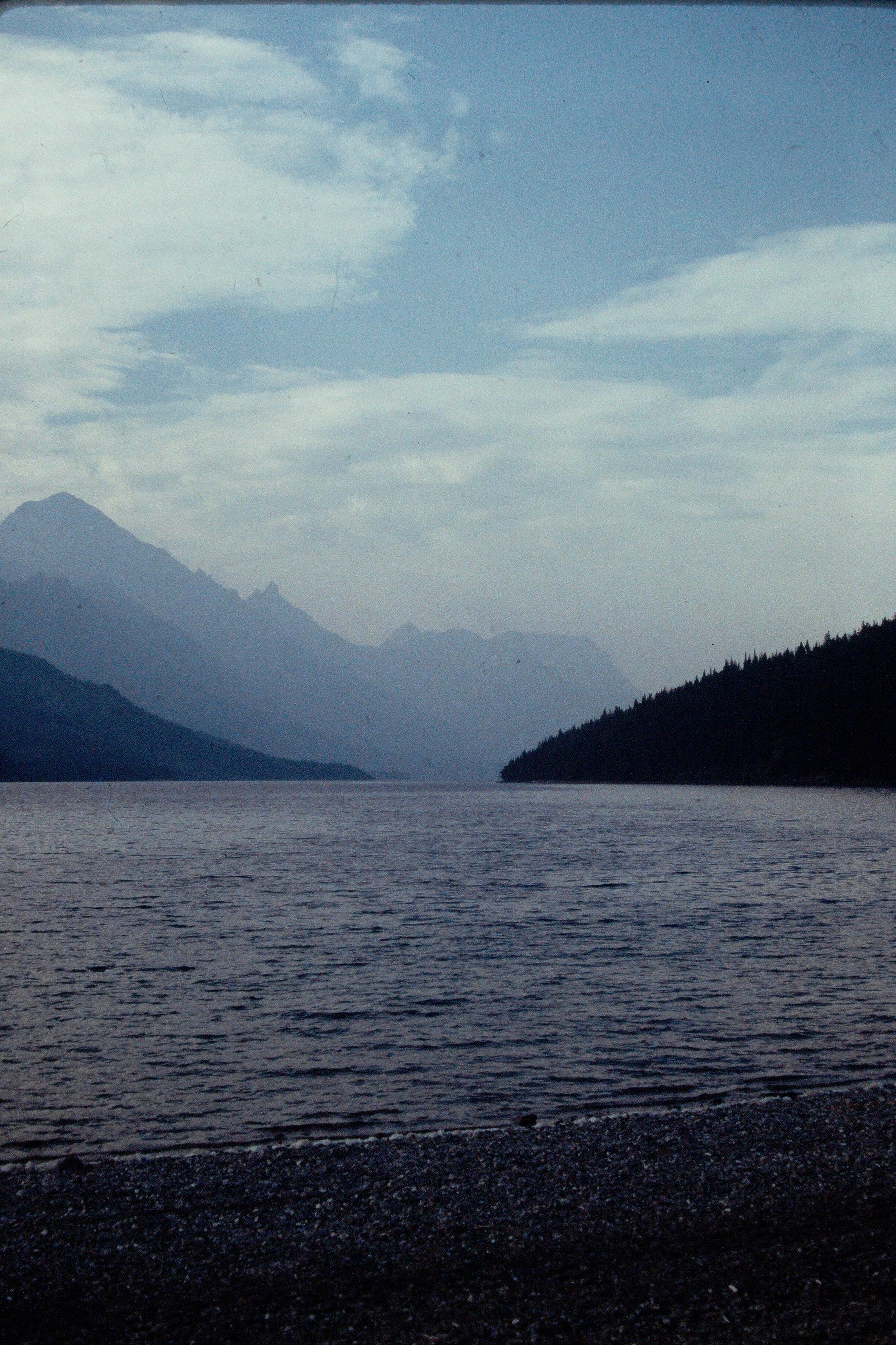
Possibly Waterton Lake
Later a Polish family in a car arrives to share our site for the night, and they insist on giving us $10 Canadian for their share.
It is cool by the lake and I sit at a picnic table near it for a long time while Ben goes off to sleep by the lake somewhere. Later I go to see Cameron Falls (?) at the other corner of the CG area on the way back into town.
There is a 10 day Bikecentennial Glacier/Waterton loop tour here. I speak with a couple of the folks on the trip, and find out that they took 2 days to ride over from St. Mary, and then a layover day here at Waterton Lakes. Tomorrow they will continue on to Bellevue, AB, about 15 miles before Crowsnest Pass.
Day 4 - Thursday, 28 July 94 - 52 miles
- Waterton Lakes, AB to Lundbreck Fall Prov. Park, AB.
After an 8:15 am restaurant breakfast in Waterton ( at $22 Canadian, about our most expensive breakfast of the trip), plus a grocery stop, we head out about 9:15 am.
Today's ride is a lot of rolling small hills, not too bad. At Twin Butte, about 15-20 miles from Waterton, the service station indicated on the Bikecentennial map looks like it's been closed at least 20 years, if not since I was born (1951)!!! Hmmm? There are definitely some errors on these maps.
We get the impression of smoky skies to the west in some gaps between the mountains today. Later we also notice the occasional smell of wood burning, and eventually realize that the pall must be the result of all the forest fires in the Pacific Northwest.
We get into Pincher Creek (about 35 miles from Waterton) around lunch time. The Bikecentennial group (?) is having lunch outside a bakery on the main street. We go farther down, but when we come to some road construction, we ask directions to the other side of town and cut through some back streets to the outskirts of town. Here there is a shopping center, as well as an A&W Root Beer place where we get some lunch. After a short stop at the shopping center we continue on through Pincher Station and onto Route 3 west headed for Lundbreck Falls Provincial Park. We take a quick break at Cowley for soda. Along this stretch it is fairly warm, mostly flat, and aside from the mountains in the distance to the west, the most notable feature of this stretch is the large wind farm of 3 bladed horizontal wind turbines, maybe 25 or 30 in all. I'm glad there is no wind to speak of today, as it would no doubt be a headwind, but the sight must be awesome in a good breeze!
Just a few miles further on, we ride into Lundbreck. Here we receive some helpful directions - instead of going back out onto Route 3 and down a big hill only to climb back up it and down again to get to the park, we are directed onto what is apparently the old Route 3 which is closed to cars at the railroad tracks partway downhill towards the park, but easily negotiated with bikes. Thus it's all downhill to the park. We arrive at Lundbreck Falls Provincial Park about 2:45 pm, find a walk-in site right next to the Crowsnest River here and pay $9 for the night. Unfortunately, there is no phone at this campground, and since I've promised to leave a status report on my voicemail box before 6 pm, I get to ride back up the hill 2.3 miles to Lundbreck to find a phone! The campground has a well for water and pit toilets in a massively built, pagoda sort of building. Much of the unused open area in the campground is populated by prairie dogs, including a couple of little guys across from our campsite who sit and scold for a while after we arrive.
Day 5 - Friday, 29 July 94 - 41 miles
- Lundbreck Falls, AB to Sparwood, BC via Crowsnest Pass
We pack up and get on the road at 8:25 am, on the lookout for someplace for breakfast (after stopping for breakfast yesterday, Ben and I decide this is a good way to get going in the mornings). We are coming back into the mountains now, and climbing ever so gradually up a long valley (Crowsnest River valley) between high mountain ridges. Bellevue is the next town about 10 miles down, but we do not find anywhere to eat, and the town as a whole is more run down than any we've seen. Looks like there is a serious economic depression here.
A couple of miles distant there is a tremendous amount of jumbled rock, and I think "This must be a closed-up mining area of some sort, and my, god, what a mess they've made out of their environment here!" At about 9:45 am, as we pass through the middle of this mess, which is spread for at least a mile on each side of the road, as well as a mile or more along the road, we arrive at a pulloff with an exhibit sign. We are at Frank Slide area - absolutely unbelievable - what a mess of rock. It seems that in the early morning hours one day back in 1903 (?), the entire side of the mountain to the southwest, approximately 800 meters by 600 meters by 500 meters (!!!!) slid off onto the sleeping town of Frank, AB, and killed about 70 people, and destroyed more than half the town. It looks like the rock just bounced in a tremendous wave a couple of miles from the mountainside! It has to be seen to be believed, really!
A short distance farther on, at about 10:00 am, we find breakfast in Frank (the "new" town). The restaurant is just a regular townie sort of place, not a tourist spot as in and around the national parks - $13.50 - good price).
We continue climbing very gradually, passing a smelly industrial area off to the left at one point. It looks like big pools of sulphur (very yellow). There is also a large teepee shaped incinerator burning wood chip and waste, which adds to the pall in the air here from the forest fires. Just before the pass, we pull into the Crowsnest Provincial CG, where Kim and Nora were planning to spend the night before meeting us in Fernie, BC, tomorrow. This is a dry, dusty, and open CG - looks like a real RV hole. There is a sign noting that the "blasting foreman" (!!!) will come and ask you to leave the picnic area by the lake at one end of the CG before they blast at the quarry next door! And you can't drink the water! We leave a note on the check-in booth (honor system typical for provincial parks in AB) for Kim and Nora to skip this place and just meet us in Sparwood. There is a pay phone, so I also leave the message on the voicemail. We finally reach the pass, which seems quite easy; we've been climbing very gradually all morning. In fact, there is no marker at Crowsnest Pass and Continental Divide, just the sign announcing "Welcome to British Columbia".
The BC roads are not quite as nice as Alberta's. Someone in "BC Highway Dept" has discovered the concrete "Jersey" barrier and there are numerous place where these have been placed taking up most of the shoulder on curves with dropoffs. In addition, the bridges on this part of Route 3 do not have shoulders, so each time we get to one, we have to watch out for vehicles, especially logging trucks, before zipping through. We arrive at Sparwood, BC, about 2:00 pm. This town is just the opposite of Bellevue, AB - it is bustling, clean, and in fact rather prosperous looking. Although we don't take advantage of it here (the CG has nice showers!), this town has a big athletic and water-sports center. We proceed to the nice town campground (Sparwood Community CG / Mountain Shadows CG - it seems to go by both names) at the far end of town. Later we meet up with Kim and Nora here while we are back at the shopping center getting groceries - they happened to call the voicemail early today and got the message just after I left it.
Note on campground following morning: lots of truck noise from Route 3 nearby. So loud I thought there was an industrial complex loading/unloading coal or ore all night! Too noisy, lousy sleep. Also, about 4 or 5 sites down, there is a bear trap! Seems they've had a bear problem, but they are pretty nonchalant about it!!
Day 6 - Saturday, 30 July 94 - rest day
- Hitched ride from Sparwood, BC to Radium Hot Springs, BC
We decided a couple of days ago that this would be a rest day while we hitched a ride with Kim and Nora to bypass the stretch of BC from Fernie to Radium Hot Springs so we would have more time available in the National Parks. The whole drive is partly cloudy, with an occasional sprinkle. As we approach Radium, the smoke pall to the west intensifies again.
Radium Hot Springs has the hottest weather so far, upper 80's but only 24% humidity. This is great! (Home - Cape Cod, MA - is probably only in the low 80's but the humidity is in the 90% vicinity typically, and can be quite oppressive, though admittedly not as bad as the cities more inland in New England). We have reserved a motel tonight, though it's not air-conditioned. There were not any other choices here - high season. But the night temperatures up here are dropping into the low 50's, so it is quite comfortable by morning.
Day 7 - Sunday, 31 July 94 - 46 miles
- Radium Hot Springs, BC (top of Sinclair Pass) to Marble Canyon CG, Kootenay NP, BC
We go to breakfast at 8:15am directly from the motel, then car ride to top of Sinclair Pass. Today is a long ride through Kootenay NP, though Kim and Nora will go on ahead and get a campsite at Marble Canyon, so we don't have any worries about finding a site. (Only later will we discover that this is not much of a worry for cyclists anyway - more later).
We unload the bikes from the van, load up (we are carrying full touring loads with camping gear in spite of meeting up with Kim and Nora at night for the next couple of days), and are on the road at 9:40 am. There is a nice long downhill to the Kootenay River then it's mostly flat for a long time, paralleling the river between the Vermillion Range on the west and the Ball Range/Continental Divide/border with Alberta on the east. At one point we see a large deer crossing the Kootenay River, but he turns back upon seeing us (I figure he thinks "Bears on wheels?!?! I'm getting out of here!"). We stop for a "lunch" break at Vermillion Crossing, and get a large bottle of Pepsi and a large, fresh coffee (couldn't resist - they'd just brewed it). While we sit at a picnic table, we talk with a guy (about 50 or so?) from Seattle who rides in from the north. He had ridden from Seattle up to Jasper and is headed south on his way to Whitefish, MT to catch the train home. He experienced headwinds most of the time, he says. He also says that wind generally blows upstream in the mountain valleys (we had a light tailwind today).
The last 15 - 20 miles climb very gradually uphill towards Vermillion Pass. There are a couple of stretches marked "No Stopping" due to avalanche danger (in winter I assume). There are definitely many slide areas on the mountain sides with just scrub brush or short trees growing. We also begin to see bits of snow and glacier on the spectacular peaks around us.
We arrive at Marble Canyon CG about 1:30 and meet Kim and Nora again just as they are heading out to hike. A little later, Ben takes a nap while I ride over to Marble Canyon info center, then hike up Marble Canyon itself. This is a pretty neat gorge, very cool from the ice cold water and spray. It has been cut by a glacier-fed milky-looking creek, and has a very high waterfall at its upper end which plunges from ground level (where you are standing) into an over-100 foot deep gorge. This gorge is only a few feet to a few INCHES wide in places, and is completely bridged by rock in a couple of spots.
Day 8 - Monday, 1 Aug 94 - 35 miles
- Marble Canyon CG, Kootenay NP, BC to Banff, AB
We hit the road at 7:45 AM and arrive at Vermillion Pass (last crossing of Continental Divide) at 8:20. There is a marker and sign here suitable for photographing, so of course we do! After a few minutes, we head out and UP (? UP? ) and finally finish climbing about 8:40!!! Love these scenic routings! We stop for breakfast at 8:45 at Storm Mountain Lodge - wow, what a spot - recommended! There is a Backroads tour group just leaving as we arrive, but I don't see any bikes, and have a feeling they were driven up here just for breakfast. The view is wonderful, though a bit foggy this morning.
After breakfast, a fast downhill takes us across TransCanada Highway 1 at Castle Junction and onto a ride along the Bow Valley Parkway (Route 1A) to Banff - very scenic, and rolling, with views of the Bow River meandering in the flats and marshes off to our right, and high mountain peaks up to our left. We keep our eyes open for moose or mountain sheep, but perhaps it is too late in the morning already, for we don't notice any today. We do see a few other loaded cyclists, the most so far, I think, and we wave our greetings to each other.
Ben and I arrive in Banff at 11:30 AM, then ride up this big hill to the campground a couple of miles from downtown at 11:45 to meet up with Kim and Nora.
Dinner is at Rose & Crown, a nice, big pub/restaurant on Banff Ave (I had very tasty steak & kidney pie for the first time in many, many years; the owners are Irish).
Ben and Nora go to the movies tonight, while Kim and I browse a lot of shops, finally ending up at a coffee shop near the theater.
Day 9 - Tuesday, 2 Aug 94 - rest day in Banff
Today is a rest day, so I ride the gondola to top of Sulphur Mountain with Kim and Nora while Ben goes to a movie by himself. Later, we visit the Cave and Basin National Historic Site, the "birthplace of Banff National Park and of Canada's National Park system". Here there are the hot mineral springs and pools that first attracted people to the area in the 19th century. We also go to the old Banff Park Museum on Banff Ave. down by the Bow River and see lots of stuffed critters from the late 1800's and early 1900's.
Tonight we get dinner at Earl's (on a side street off Banff Ave. kind of opposite the NP info center). Its got an interesting decor - 3 ft tall plastic parrots by the dozens - and the food is good.
This evening Ben and Nora go to another movie (Have we been on vacation too long for a 23 year old or a 14 year old?) Kim and I just take it easy in the park by the Bow River (tomorrow we will separate again for several days til we rendezvous at the Icefields Visitor Center in Jasper National Park).
Day 10 - Wednesday, 3 Aug 94 - 42 miles
- Banff, AB to Lake Louise, AB
Ben and I say good bye and are on the road at 8:30 AM. Soon we stop at a mountain sheep "jam" on the Bow Valley Parkway and take a couple of pictures before deciding it's safe to slip by on bikes! We still have not seen any moose or bears. We get breakfast at Johnston Canyon at 10:15, $22.40 - it's expensive again in these NP concessions. After passing through Castle Junction, we are in new territory again, riding through the flats of the Bow River valley and paralleling Highway 1 and the railroad. In the area near Protection Mountain CG, there are temporary bear-warning signs and red tape along the trees on the west side of the road along the railroad tracks. Evidently they have been having a bear problem near this CG lately. Naturally, we do not see any bears.
When we arrive at Lake Louise about 1:30 pm, the tent campground is supposedly full (they are turning vehicles away in front of us) but because we are on bicycles, we get sent to another ranger at the check-in, who simply assigns us a regular site for $12.50! Here we finally find out that Canadian NP policy (unwritten?) is to not turn away cyclists or hikers (since they can't just go to some other CG or whatever), but to find someplace to put them (remember we were asked if we'd share our site back at Waterton Lakes NP). When we get to our site, there appear to be quite a few sites still empty - maybe they actually hold some aside for bikers/hikers - I don't know (or ask), but do notice that many of our neighbors are on foot or bikes. We set up camp and put our food and stuff in the bear-proof lockers nearby.
At about 3:00 pm, Ben and I ride up (UP!) to Lake Louise itself. A 10 minute rain shower hits us during the climb but it is sunny the whole time at the lake. There are lots of people at the lake, and unfortunately, more litter than I've seen in the parks on the entire trip. But the views here are very spectacular! This is a beautiful turquoise-blue glacial lake set amongst spectacular peaks and glaciers along the Continental Divide. We spend almost an hour here, just sitting and taking in the view. It's easy to see why there is a huge hotel (Chateau Lake Louise) here and people have been coming here since the railroad arrived a hundred years ago.
We return to the village shopping center to do some laundry and have some lunch/supper, which is good, but $16. Later we spend another $8 for milk, brownies, coffee, soda. While doing laundry, a thunderstorm moves through. There is heavy rain at one point around 4:30 PM then slow clearing, but since it's too rainy at the moment to go back to the campsite, we hang around under the wide overhangs of the building with the laundromat and talk for a long time with an unemployed computer programmer from San Diego who started biking several weeks ago from Utah. He is headed up to Jasper, then Vancouver, then part way down the Pacific coast, as far as he can get by the end of August at least. After the rain finally stops, Andras (he is from the Transylvania region of Romania originally) decides to continue on north a little farther this evening.
Ben is having increasing pain in his right Achilles tendon, but thinks he will be able to keep going tomorrow. This is an omen of things to come.
Day 11 - Thursday, 4 Aug 94 - 60 miles
- Lake Louise, AB to Rampart Creek Hostel via Bow Pass
While it did not rain all night, and the stars were visible occasionally, dawn is mostly cloudy, though with some small blue patches. I hope it doesn't rain, and it never does today.
We begin the day with breakfast in the village at 8:10 AM. Ben's ankle is stiff and sore, but he feels he can still ride. We are on the road at 9:15, but after only a few miles, just beyond the split between the Icefields Parkway (RT 93) and the TransCanada (RT 1), Ben's right ankle (tendon) is hurting pretty badly. We stop for a few minutes and consider turning back to Lake Louise or having him hitch a ride. He decides to keep plugging along. At some point he lowers his seat 1/2" which reduces the strain on the tendon; also he is warming up with the riding.
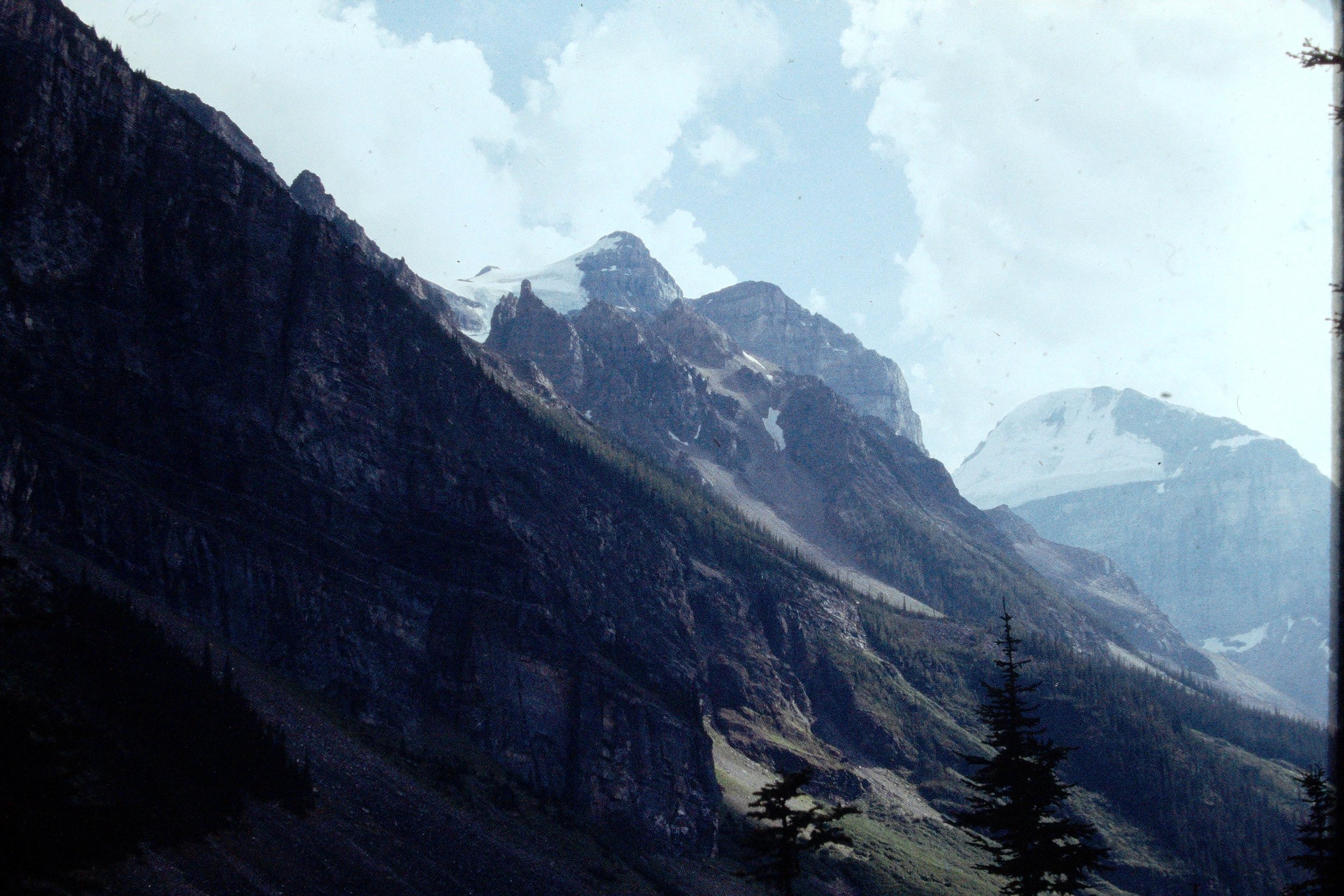
The scenery today is spectacular. Glaciers hanging all over the place. The road is good also. Somewhere along here we leapfrog a Backroads Tours group again while they are stopped taking pictures. I don't think I took enough pictures, but then pictures just can't do justice to these mountains.
There is too much traffic though - too bad. Well, actually, relative to Cape Cod in summer, there is NO traffic here :-), but there is probably too much for this area. At the pass for example, we look for a toilet or outhouse at a trailhead parking area, but there is only evidence of a former one now removed - I suspect there were too many people for this environment.
We reach the top of Bow Pass at about 12:40. After the pass, the downhills make it easier. The scenery on either side continues to be breathtaking. The riding is not too hard now and we get to the junction with the David Thompson Highway about 2:30 pm.
Lunch at the Saskatchewan Crossing cafeteria is $16.50 - too expensive but we needed fuel and rest. Ben decides he wants Kim to pick him up at the hostel tomorrow and at least take him to the top of Sunwapta Pass. His right Achilles tendon is very sore now. I leave a message for Kim to that effect, but plan to ride up the pass myself early in the morning. We run into Andras (the guy we met at Lake Louise yesterday) while having lunch and he rides with us to the hostel, then continues on toward the next campground. We finally get to Rampart Creek Hostel at 4:30 pm.
Day 12 - Friday, 5 Aug 94 - 35 miles
- Rampart Creek Hostel to Beauty Creek Hostel via Sunwapta Pass
I head out alone on the road at 7:20 AM. :-( Ben will wait for a ride later this morning. His ankle has had it and he is limping noticeably.
It is cool this morning and the first few miles are in shadow and fairly flat. I pass the area that used to be Cirrus Mountain campground, but nearly all traces of it have been bulldozed and seeded. The fading paint of the turn lane in the parkway here is the most obvious indicator of the former entrance. A little farther on, the first climbing begins rather steeply. After a mile or so the road levels out to cross a bridge over a high ravine with a spectacular waterfall below out of sight of the motorists zooming by. The parkway now runs along almost level then slightly downhill (!! oh, no - don't waste that climbing!) to a broad switchback on what appears to be former river flood plain before the start of the really serious climbing of Sunwapta Pass. The next couple of miles are very steep; later at the top I see a sign for traffic headed the other way which indicates 8% for the grade - wow, the steepest on the trip. It's a good thing it's only a couple of miles. My granny gear is not that low, and the air is 6500 ft thin, so I stop a couple of times to catch my breath and drink water - can't ride and drink at the same time here. Except for this 2 mile steep section though, the rest is not too tough. I reach Sunwapta Pass at 9:45 AM, after a slight downhill on a broad curve by the Hilda Creek hostel then a final climb for another mile or two up to the top of the pass. I lean my bike against the sign for the pass and take a picture. I wish Ben was with me, but I'm looking forward to seeing everyone in a couple of hours at the Icefields Visitor Center.
A couple of miles after the pass, there is a hotel and restaurant opposite the foot of the Athabasca Glacier. I stop for breakfast here at 10:05 am - $14.00 is expensive but I'm really starved! Suppose I should qualify "expensive" breakfast - it was 2 eggs, sausage, toast, homefries, 2 milks, orange juice, coffee, and banana, so maybe that's why it was $14.00 (Canadian, of course)!!
Andras showed up for breakfast also. He made it to Hilda Creek Hostel just before the pass (but after the steep switchback section) last night at dusk, having discovered to his dismay that the Cirrus Mountain CG was no more! At the hostel they said that the final straw for the CG, which sat in the shadow of very steep cliffs, was the large boulder that fell into the middle of the campground one night.
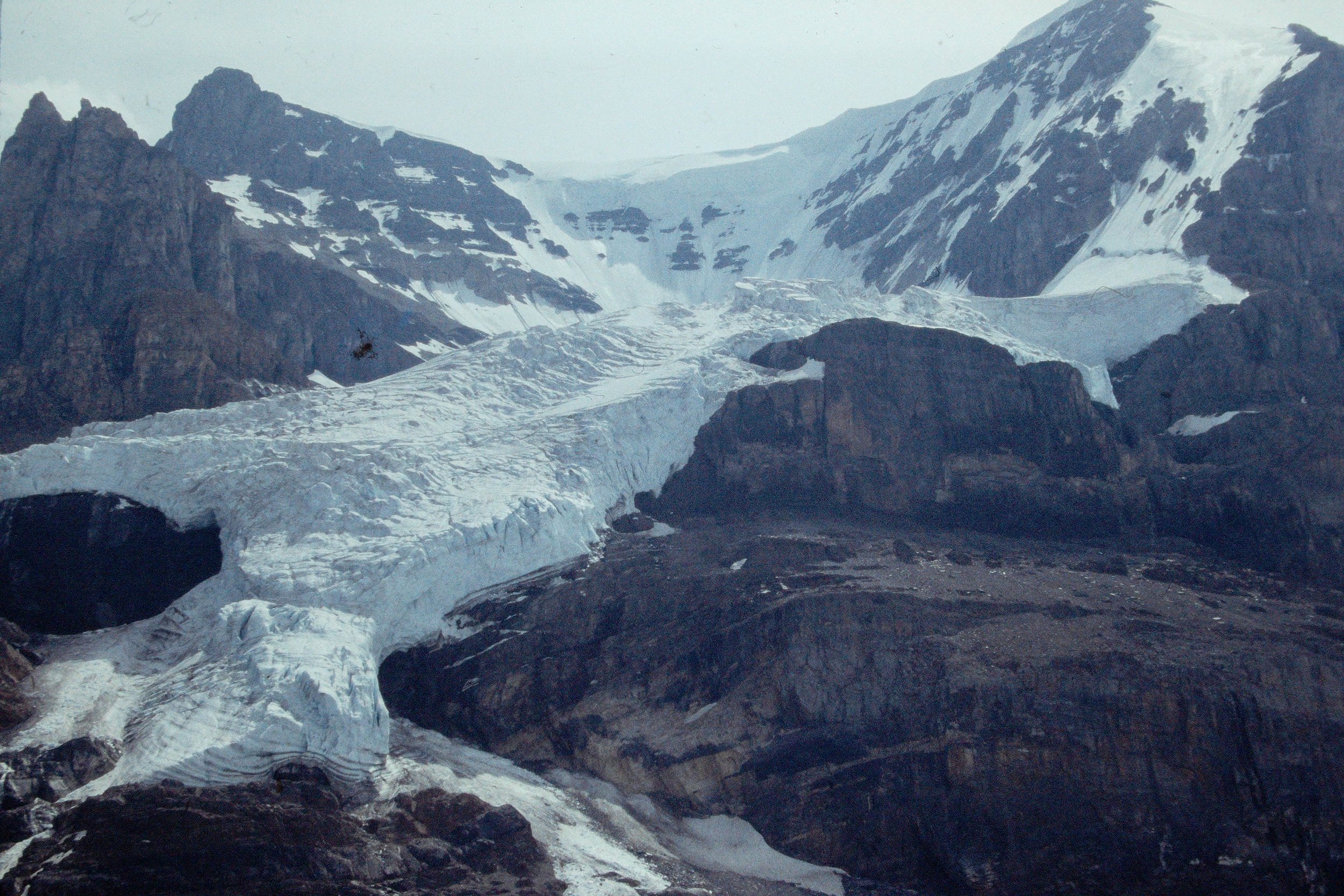
Kim, Nora and Ben pull in and find me during breakfast here. We head down the road a few hundred yards to the Icefields Visitor Center and spend the next few hours there. Nora and I take a snocoach tour up onto Athabasca Glacier - neat! We hang around at the Visitor Center long enough for a thunderstorm to go through just as I am about to leave. I wait for it to pass then head down, but pause again farther on as I am trying to stay behind another large thunderstorm.

Road note: the road DOWN from pass (after the Icefields Center) has a piece of what feels like 8% UP (for scenic purposes by a gorge on the Athabasca River, I suspect) followed finally by a long piece of 8% down that's a bit scary as the shoulder is rough and has gravel in some places.
I arrive at Beauty Creek Hostel at 4:45 PM. This is a very "rustic" hostel but if you want to boil enough water, you can have an outside shower. Another big thunderstorm goes through about 6:30 PM so I don't bother with shower.
It seems at least half the people here are German. A fellow from Berlin walks in just as I do so I "give" him Ben's reservation and avoid having to pay for Ben's no-show.
Day 13 - Saturday, 6 Aug 94 - 52 miles
- Beauty Creek Hostel to Jasper, AB
I hit the road for the final day at 7:35 AM. It is a very cold (45F ?) and foggy ride for the first 20 miles this morning; the sun is fitfully trying to break through, but doesn't succeed for a while. The mountain tops on either side are hidden in clouds and mist as I travel along the valley floor between. I arrive at Sunwapta Falls for breakfast at 8:45 AM. The Backroads tour group is here just finishing breakfast and getting ready to leave for Jasper also. Though they leave while I'm still eating, I catch and pass them later, much to their chagrin, as I'm heavily loaded and they are carrying nothing. Incidentally, by this time, the clouds have lifted and the sun is shining on the surrounding mountaintops.
At Athabasca Falls, per the Bikecentennial map as well as the recommendation of the Backroads tour leaders, I take 93A, the "scenic" route into Jasper. This was AGAINST the recommendation of the Beauty Creek Hostel manager, who said it was potholed, shoulderless, narrow and hilly with too many RV's.
Athabasca Falls is pretty spectacular. There is an amazing amount of water in these milky, glacier-fed rivers and streams during August, compared to the typical snow runoff streams which are very low or dry at this season. Immediately after the falls, the road turns to garbage and climbs hard away from the river! A dozen miles and a few RV's (not bad) later I hit a pretty good grade (another 8% ??) for a while up to the junction with Edith Clavell Mtn. Road, but there is a nice downhill after. There were some flats along the river before this point, but for the most part the road is closely tree-lined with a narrow stripe of sky visible above. Thus, I would recommend staying on Route 93 into Jasper to anyone - it's the main parkway, with its wide shoulders and BIG, panoramic views of the mountains that I at least certainly came here to see. I could ride down a narrow, tree- lined, hilly road at home and see the same narrow stripe of blue sky above. Just my opinion.
I arrive at the campground in Jasper at 11:45 AM. The arrival is somewhat anti-climactic. I wish Ben was along til the end. But, I made it! And I'm glad to be at the finish and back with my family.
After meeting everyone at the CG, we go into town to the Jasper Aquaplex (?) - a water-sports center with large swimming pool, large whirlpool, water slide, and kiddy pool. For a couple of dollars, you can relax, soak those tired muscles, and get clean (the last easy showers, by the way, were back in Banff). This facility is located a couple of blocks west of the main street, and I noticed that the Backroads group was wrapping up their ride here also. Recommended. In fact, look for these facilities wherever you are in Canada - we've noticed them in quite a few somewhat unlikely places.
*****************************************************************
Miscellaneous "statistics":
Miles ridden: 462 route miles (not counting running around in towns)
Average speed: 10 - 11 MPH rolling (guesstimate based on a few random checks of Ben's cylometer)
Passes ridden: Logan Pass, Crowsnest Pass, Vermillion Pass, Bow Pass (highest at 6788 ft), Sunwapta Pass
Biggest climb: Logan Pass - about 3000 feet in 11 miles
Hardest climb: the switchback on Sunwapta Pass, about 2 miles
Toughest day: St. Mary, MT to Waterton Lakes, AB - almost no services, no water
# of bears seen: None
# of moose seen: None
Ben's Bike: Trek 8700 mountain bike, slick tires, Nashbar Mountain rear panniers, Jandd seat tool bag, Jandd handlebar bag, 2 large water bottles, plus sleeping bag, thermarest pad, and Eureka 3-man tent and a bunch of Nikon F3 stuff. Weight unknown.
Geoff's Bike: Cannondale T1000 touring bike, Continental Super Sport 27x1.25 tires with Mr. Tuffy tire liners, Cannondale large rear panniers, Rhode Gear small front panniers, Cannondale seat tool bag, Cannondale large handlebar bag, plus sleeping bag and thermarest pad. I carried food and cooking gear. Weight of bike and load about 70 lbs.
Mechanical problems: None (unless you count Ben's Achilles tendon troubles). No flats!
*****************************************************************
All in all, a great trip. I'd do it again in a minute (maybe not the long drive, though :-) If you use the Bikecentennial/Adventure Cycling maps, be sure to interpret the route profiles with a LARGE grain of salt. Also, don't bring an untested camera like I did just because it's small - my slides were of disapointing quality. Bring that big old Nikon and a lense or two - the extra weight is an insignificant price to pay for good pictures. And if you bring that camera, stop more often, take more photos - it's tough to go back later!
Geoff Allsup